
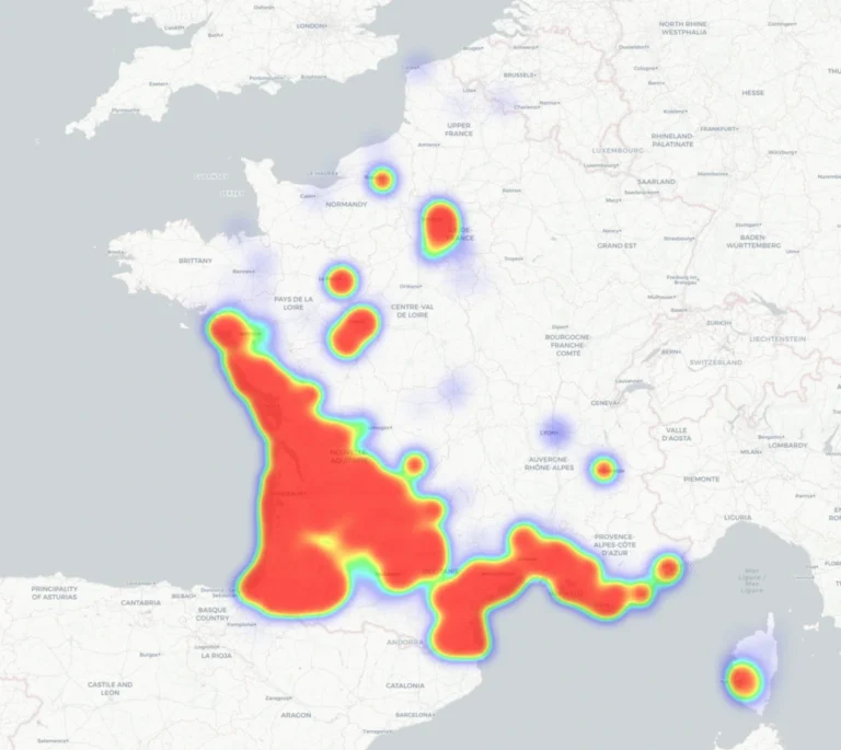
A termite map cannot be interpreted correctly without knowing its source, date, and legend. Depending on the document consulted, it may represent regulatory zoning established by prefectural decree, observations of infestation, or data from field surveys. Therefore, the same color does not necessarily have the same meaning from one map to another.
Understanding what the map shows helps prevent jumping to conclusions: land-use zoning alone does not reveal the condition of a building, and the absence of a regulatory classification does not guarantee the absence of termites.
If you’d like a comprehensive overview of the topic, be sure to check out our comprehensive guide to termites. There you’ll find detailed explanations of how they operate, signs of infestation, the risks to a home, and the main prevention and treatment options.
5 Things to Know Before Consulting a Termite Map
- First, check what the map shows: regulatory zoning, pest infestation reports, or field data
- A zoning map alone is not enough to determine the condition of a building
- An area designated by a prefectural order does not mean that all buildings are infested
- The absence of regulatory zoning does not guarantee the absence of termites
- Always check the source, the date it was updated, and the legend before interpreting a map
Termite Map: How to Interpret It Quickly?
| What the map represents | What You Can Conclude From This |
| Zoning by Prefectural Order | The territory falls within a regulatory boundary defined by the prefect |
| Observed occurrences or infestations | Termites have been reported or observed in the area shown |
| Data from interventions | The map reflects observations based on field data provided by its publisher |
| No colored area | It should be interpreted as indicated in the legend: it does not necessarily prove the absence of termites |
Do all termite maps show the same thing?
No. A map based on prefectural decrees represents regulatory zoning, whereas a map of infestations or sightings is based on field data. Other maps can also be created based on interventions carried out by a professional network.
Before interpreting a map, you must therefore identify its source and legend. Two termite maps can both be relevant while still depicting different information.
How do you read a map based on a prefectural decree?
When one or more termite infestations are identified, a prefectural order delineates the areas that are infested or likely to become infested in the near future. A regulatory map therefore depicts the perimeter defined by this order; it does not constitute a comprehensive inventory of all infested buildings.
To understand how this zoning is established and how it may change, see our feature on termite-risk zones.
Why might the zoning shown on a map change?
The boundaries defined by prefectural decree may change as the territorial situation evolves. Maps depicting these decrees must therefore also be updated. Other maps, based on observations or interventions, may change depending on their own data.
The update date is therefore an important piece of information to check before making any interpretations.
What does an area designated by a prefectural order mean on a map?
An area designated by prefectural order is defined as a territory that is contaminated or likely to become contaminated in the short term, as defined by the Code of Construction and Housing. This territorial classification does not mean that all buildings located within it are infested.
It may, however, have regulatory implications. When selling a home located in an affected area, a termite inspection report must be provided to the buyer.
No classification: no risk?
No. The absence of a classification means that, as of the date of verification, the municipality or area in question is not subject to the regulatory zoning shown on the map. It does not mean that there are no termites in any of the buildings within that area.
Good to know
A regulatory map should be interpreted as a representation of administrative zoning, not as an exhaustive list of every infestation.
Why might two termite maps look different?
Two termite maps may use different sources, update dates, and scales. One may show the prefectural ordinances currently in effect, while another may be based on observed infestations or field interventions.
A difference between two maps does not necessarily mean that one of them is incorrect. Before comparing them, check what each one depicts, its legend, its source, and its date of last update.
How do you actually use a termite map?
A termite map should be used as:
- a decision-making tool,
- a starting point, never a definitive conclusion.
In particular, it allows you to:
- check, using a regulatory map, whether a territory is subject to a prefectural order,
- understand the local context,
- Understand in which situations a termite inspection is required.
Termite Maps and Inspections: Understanding the Difference
The Termite Map:
- provides information about a regional risk,
- It is never a substitute for a building-wide analysis.
A regulatory termite inspection examines a specific property on a given date, using a standardized method and limited to the areas to which the inspector has access.
The two approaches are complementary, but serve different purposes.
If your municipality is affected, find out how to determine whether your home actually poses a risk.
Termite inspection or assessment: What’s the difference?
| Termite Map | Termite Inspection |
| Leads to a region | Door to a building |
| Provides information on a risk level | Check for an infestation |
| Based on data specific to the map being viewed | Is based on a technical review |
| Guides decision-making | Checks for the presence of termites in the building being inspected |
Where can I find a reliable and up-to-date termite map?
The choice of map depends on the information you’re looking for.
• The map of termites in France provided by Sentri Tech is based on observations made during its fieldwork.
• To verify regulatory zoning, the Cerema’s national mapping can be used to determine whether a municipality or department is subject to a prefectural order.
• The FCBA’s National Termite Observatory also offers a departmental map of infestations, based on site declarations from CTB-A+ certified companies, as well as a map of prefectural decrees. For the latter, the Observatory specifies that town halls and prefectures remain the official source.
In summary
To properly interpret a termite map, start by identifying what it depicts: regulatory zoning, infestation observations, or data from treatment operations. Next, check its source, legend, and date of last update.
A map helps place a property in its geographical context, but it is not sufficient on its own to determine a building’s status. Depending on your needs, you may need to consult the applicable prefectural order or have the dwelling inspected.
Questions you might have
Can a termite map tell me if my house is infested?
No. A map provides geographic information based on the data it represents. It cannot, on its own, determine whether a specific building is infested.
Are the termite maps updated regularly?
It depends on the publisher and the data used. In particular, a regulatory map must take into account changes in prefectural decrees, while a map based on observations can be updated as new data becomes available.
Should I look at a map before buying a house?
This is a useful check for understanding the property’s geographical context. If the property is located in an area designated by a prefectural order, the seller must provide the termite inspection required by law.
Where can I find official information?
To find out which regulatory zoning applies, contact the relevant prefecture and consult public resources that allow you to view prefectural decrees, particularly the Cerema’s national map.